Stanford researchers create robotic boot that helps people walk

Engineers at Stanford University have created a boot-like robotic exoskeleton that can increase walking speed and reduce walking effort in the real world outside of the lab. The team’s research was published in Nature

The exoskeleton gives users personalized walking assistance, allowing people to walk 9% faster and use 17% less energy per distance traveled. The energy savings and speed boost that the exoskeleton provides is equivalent to taking off a 30-pound backpack, according to the team. 

The goal is to help people with mobility impairments, especially older people, to more easily move throughout the world, and the Standford team believes that its technology will be ready for commercialization in the next few years. 

Using a motor that works with calf muscles, the robotic boot gives wearers an extra push with every step. The push is personalized using a machine learning-based model that was trained through years of work with emulators, or large, immobile and expensive lab setups that can rapidly test how to best assist people. 

Students and volunteers were hooked up to the exoskeleton emulators while researchers collected motion and energy expenditure data. This data helped the research team to understand how the way a person walks with the exoskeleton relates to how much energy they’re using. The team gained more details about the relative benefits of different kinds of assistance offered by the emulator, and used the information to inform a machine-learning model that the real-world exoskeleton now uses to adapt to each wearer. 

To adapt to an individual’s unique way of walking, the exoskeleton will provide a slightly different pattern of assistance each time the user walks. The exoskeleton then measures the resulting motion so that the machine learning model can determine how to better assist the user the next time they walk. In total, it takes the exoskeleton about an hour to customize its support to a new user. 

Moving forward, the Stanford researchers hope to test what the exoskeleton can do for its target demographic, older adults and people who are experiencing mobility decline from disability. The team also wants to plan design variations that target improving balance and reducing joint pain, and work with commercial partners to turn the device into a product. 

The post Stanford researchers create robotic boot that helps people walk appeared first on The Robot Report.

Developing open-source systems for first responder legged robots

open source bipedal robots university of michiganDigit, a bipedal robot from Agility Robotics, being tested at the University of Michigan. | Photo Credit: Joseph Xu/University of Michigan Engineering

Tomorrow’s wildfire fighters and other first responders may tag-team with robotic assistants that can hike through wilderness areas and disaster zones, thanks to a University of Michigan research project funded by a new $1 million grant from the National Science Foundation.

A key goal of the three-year project is to enable robots to navigate in real time, without the need for a pre-existing map of the terrain they’re to traverse. The project aims to take bipedal (two-legged) walking robots to a new level, equipping them to adapt on the fly to treacherous ground, dodge obstacles or decide whether a given area is safe for walking. The technology could enable robots to go into areas that are too dangerous for humans, including collapsed buildings and other disaster areas. It could also lead to prosthetics that are more intuitive for their users.

“I envision a robot that can walk autonomously through the forest here on North Campus and find an object we’ve hidden. That’s what’s needed for robots to be useful in search and rescue, and no robot right now can do it,” said Jessy Grizzle, principal investigator on the project and the Elmer G. Gilbert Distinguished University Professor of Engineering at U-M.

Grizzle, an expert in legged robots, is partnering on the project with Maani Ghaffari Jadidi, an assistant professor of naval architecture and marine engineering and expert in robotic perception. Grizzle says the pair’s complementary areas of expertise will enable them to work on broader swathes of technology than has been possible in the past.

To make it happen, the team will embrace an approach called “full-stack robotics,” integrating a series of new and existing pieces of technology into a single, open-source perception and movement system that can be adapted to robots beyond those used in the project itself. The technology will be tested on Digit and Mini Cheetah robots.

“What full-stack robotics means is that we’re attacking every layer of the problem at once and integrating them together,” Grizzle said. “Up to now, a lot of roboticists have been solving very specific individual problems. With this project, we aim to integrate what has already been done into a cohesive system, then identify its weak points and develop new technology where necessary to fill in the gaps.”

mini cheetah robot university of michigan

A Mini-Cheetah robot at The University of Michigan. | Photo Credit: Robert Coelius, University of Michigan Engineering.

One area of particular focus will be mapping – the project aims to find ways for robots to develop rich, multidimensional maps based on real-time sensory input so that they can determine the best way to cover a given patch of ground.

“When we humans go hiking, it’s easy for us to recognize areas that are too difficult or dangerous and stay away,” Ghaffari said. “We want a robot to be able to do something similar by using its perception tools to build a real-time map that looks several steps ahead and includes a measure of walkability. So it will know to stay away from dangerous areas, and it will be able to plan a route that uses its energy efficiently.”

Grizzle predicts that legged robots will be able to do this using math – for example, by calculating a standard deviation of ground height variation or how slippery a surface is. He plans to build more sophisticated perceptual tools that will help robots gather data by analyzing what their limbs are doing—a slip on an icy surface or a kick on a mogul, for example, would generate a new data point. The system will also help robots navigate loose ground and moving objects, such as rolling branches.

Rich and easily understandable maps, Ghaffari explained, will be equally important to the humans who may one day be operating those robots remotely in search-and-rescue operations or other applications.

“A shared understanding of the environment between humans and robots is essential, because the more a human team can see, the better they can interpret what the robot team is trying to accomplish,” Ghaffari said. “And that can help humans to make better decisions about what other resources need to be brought in or how the mission should proceed.”

Agility Robotics, developer of the Digit robot, recently released the video below showcasing how its humanoid robots are being tested in warehousing applications.

The post Developing open-source systems for first responder legged robots appeared first on The Robot Report.

Drone deliveries could change logistics networks, finds University of Texas at Dallas

Drone deliveries could change logistics networks, finds University of Texas at Dallas

As drone deliveries get faster, they will affect retail, said researchers. Source: The University of Texas at Dallas

After contending with a static consumer demand and regulatory restrictions, aerial drones have found commercial applications in agriculture, construction, infrastructure inspection, real estate, and more. Researchers at The University of Texas at Dallas last week said drones deliveries could enable retailers to offer unheard-of lead times and near-perfect delivery-time customization adaptability.

In a new study, recently published online in Production and Operations Management, three faculty members from the Naveen Jindal School of Management explored how drone delivery could change retail logistics networks. The paper focuses on the use of customer-facing delivery centers, also known as last-mile warehouses.

Dr. Milind Dawande, professor of operations management and one of the paper’s co-authors, said last-mile retail drone deliveries are being viewed as a truly disruptive technology. Retailers worldwide are pursuing approaches to enable faster delivery, and drones arguably represent the most encouraging technological innovation toward this goal, he said.

Drone deliveries may lead to decentralized networks

The study found that both the number of last-mile warehouses and the speed of drone deliveries will increase as technology matures. In other words, last-mile delivery networks will become more decentralized, with drones operating at increasingly faster speeds.

Dr. Milind Dawande

Dr. Milind Dawande. Source: The University of Texas at Dallas

The analysis also showed that while perfect customization of delivery-time guarantees is more profitable, retailers can capture a sizable portion of the profit by partitioning their market into a few zones and offering the best-possible delivery-time guarantee for each zone.

“If a retailer promises each customer a different delivery time based on the customer’s location, that would be perfect customization,” Dawande said. “For example, a retailer could give any customer who is one mile away a delivery-time guarantee of five minutes and a customer 1.5 miles away a delivery-time guarantee of seven minutes.”

“While perfect customization is theoretically best for the retailer, it is impractical. Instead, the retailer might offer all customers less than five miles away a guaranteed delivery time of 15 minutes,” he added. “In other words, limited customization is good enough.”

Faster drone deliveries are more profitable because it implies more demand, Dawande said. Customers’ needs are time-sensitive. For example, if a retailer promises delivery of a book in 15 minutes, the demand is likely to go up, as compared to a three-day delivery promise.


The Robot Report Podcast: Are Amazon drone deliveries coming? And robotics investment trends


The researchers noted that increasing speed of drone deliveries can help improve profitability only if it is accompanied by an increase in the number of last-mile warehouses. Therefore, in congested markets, where the number of warehouses cannot be increased, the retailer may find it best to offer a delivery speed that is lower than the highest-possible speed.

Before drone technology can become widely adopted, however, privacy and safety issues need to be solved, Dawande said, as well as regulations coordinating drone travel and the public perception of fleets of drones flying overhead. The paper points to pilot programs testing the technology.

“It would be reasonable to assume that drone technology is maturing quickly, and we should see a commercial rollout on a larger scale in the not-too-distant future. The COVID-19 pandemic will perhaps hasten this process,” said Dawande, who is also the Mike Redeker Distinguished Professor in Management.

Dr. Ganesh Janakiraman

Dr. Ganesh Janakiraman

Drone deliveries might be particularly appealing to customers concerned about both safety and speed, he said. Hands-free delivery to one’s doorstep will be an advantage drones can offer in the post-COVID-19 era.

The analysis is also applicable to other dedicated delivery vehicles, such as delivery robots and electric bikes, which many retailers are testing.

The researchers noted that further research is needed into how last-mile delivery capacity might be allocated between drones and traditional approaches such as delivery trucks.

On the one hand, drone delivery can enable fast delivery times and minimize the cost of human labor by using dedicated aerial vehicles that fly directly from a delivery center to the customer’s location.

Dr. Vijay Mookerjee

Dr. Vijay Mookerjee

On the other hand, delivery trucks have the capability of making multiple stops during a trip. The researchers predict that retailers will use both in order to benefit from their respective strengths.

Dr. Ganesh Janakiraman, Ashbel Smith Professor of operations management, and Dr. Vijay Mookerjee, the Charles and Nancy Davidson Chair in Information Systems, also contributed to the study.

The lead author is former student Sandun Perera, who is now an assistant professor of managerial sciences at the University of Nevada, Reno.

The post Drone deliveries could change logistics networks, finds University of Texas at Dallas appeared first on The Robot Report.

Semantic SLAM navigation targets last-mile delivery robots

last-mile delivery robots

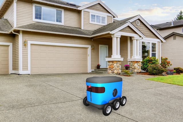
Last-mile delivery robots could use an MIT algorithm to find the front door, using environmental clues. | Credit: MIT

In the not too distant future, last-mile delivery robots may be to drop your takeout order, package, or meal-kit subscription at your doorstep – if they can find the door.

Standard approaches for robotic navigation involve mapping an area ahead of time, then using algorithms to guide a robot toward a specific goal or GPS coordinate on the map. While this approach might make sense for exploring specific environments, such as the layout of a particular building or planned obstacle course, it can become unwieldy in the context of last-mile delivery robots.

Imagine, for instance, having to map in advance every single neighborhood within a robot’s delivery zone, including the configuration of each house within that neighborhood along with the specific coordinates of each house’s front door. Such a task can be difficult to scale to an entire city, particularly as the exteriors of houses often change with the seasons. Mapping every single house could also run into issues of security and privacy.

Now MIT engineers have developed a navigation method that doesn’t require mapping an area in advance. Instead, their approach enables a robot to use clues in its environment to plan out a route to its destination, which can be described in general semantic terms, such as “front door” or “garage,” rather than as coordinates on a map. For example, if a robot is instructed to deliver a package to someone’s front door, it might start on the road and see a driveway, which it has been trained to recognize as likely to lead toward a sidewalk, which in turn is likely to lead to the front door.

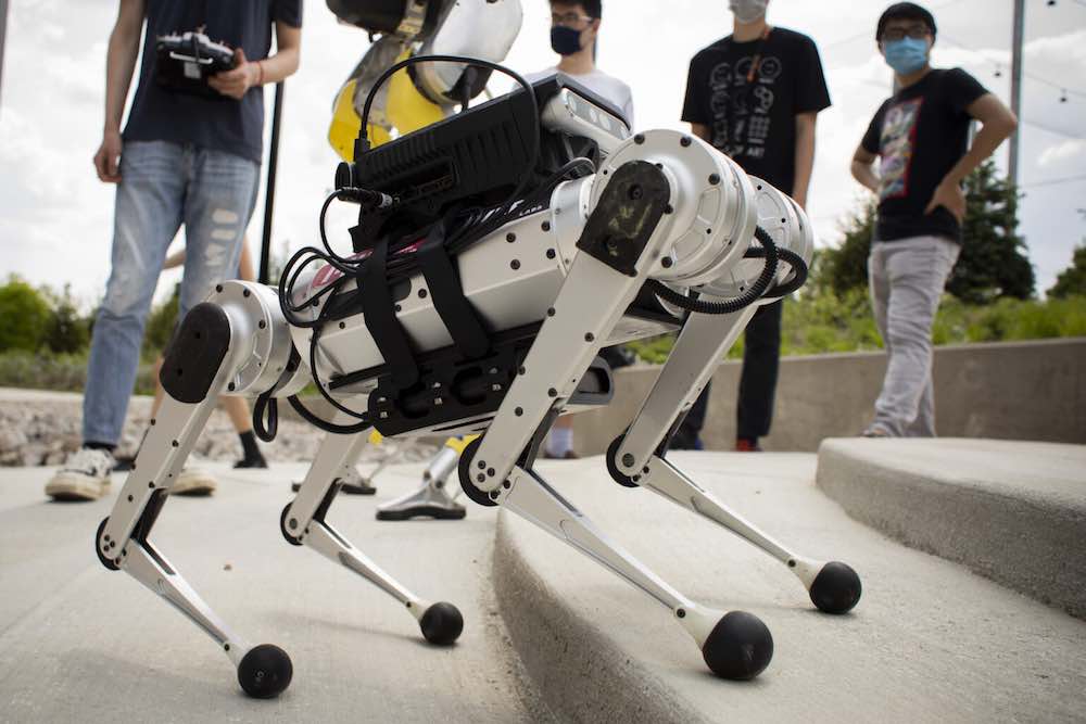
Related: Delivery tests combine autonomous vehicles, bipedal robots

The new technique can greatly reduce the time last-mile delivery robots spend exploring a property before identifying its target, and it doesn’t rely on maps of specific residences.

“We wouldn’t want to have to make a map of every building that we’d need to visit,” says Michael Everett, a graduate student in MIT’s Department of Mechanical Engineering. “With this technique, we hope to drop a robot at the end of any driveway and have it find a door.”

Everett presented the group’s results at the International Conference on Intelligent Robots and Systems. The paper, which is co-authored by Jonathan How, professor of aeronautics and astronautics at MIT, and Justin Miller of the Ford Motor Company, is a finalist for “Best Paper for Cognitive Robots.”

“A sense of what things are”

In recent years, researchers have worked on introducing natural, semantic language to robotic systems, training robots to recognize objects by their semantic labels, so they can visually process a door as a door, for example, and not simply as a solid, rectangular obstacle.

“Now we have an ability to give robots a sense of what things are, in real-time,” Everett says.

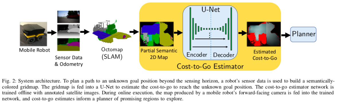
Everett, How, and Miller are using similar semantic techniques as a springboard for their new navigation approach, which leverages pre-existing algorithms that extract features from visual data to generate a new map of the same scene, represented as semantic clues, or context.

In their case, the researchers used an algorithm to build up a map of the environment as the robot moved around, using the semantic labels of each object and a depth image. This algorithm is called semantic SLAM (Simultaneous Localization and Mapping).

While other semantic algorithms have enabled robots to recognize and map objects in their environment for what they are, they haven’t allowed a robot to make decisions in the moment while navigating a new environment, on the most efficient path to take to a semantic destination such as a “front door.”

“Before, exploring was just, plop a robot down and say ‘go,’ and it will move around and eventually get there, but it will be slow,” How says.

The cost to go

The researchers looked to speed up a robot’s path-planning through a semantic, context-colored world. They developed a new “cost-to-go estimator,” an algorithm that converts a semantic map created by pre-existing SLAM algorithms into a second map, representing the likelihood of any given location being close to the goal.

“This was inspired by image-to-image translation, where you take a picture of a cat and make it look like a dog,” Everett says. “The same type of idea happens here where you take one image that looks like a map of the world, and turn it into this other image that looks like the map of the world but now is colored based on how close different points of the map are to the end goal.”

This cost-to-go map is colorized, in gray-scale, to represent darker regions as locations far from a goal, and lighter regions as areas that are close to the goal. For instance, the sidewalk, coded in yellow in a semantic map, might be translated by the cost-to-go algorithm as a darker region in the new map, compared with a driveway, which is progressively lighter as it approaches the front door — the lightest region in the new map.

The researchers trained this new algorithm on satellite images from Bing Maps containing 77 houses from one urban and three suburban neighborhoods. The system converted a semantic map into a cost-to-go map, and mapped out the most efficient path, following lighter regions in the map, to the end goal. For each satellite image, Everett assigned semantic labels and colors to context features in a typical front yard, such as grey for a front door, blue for a driveway, and green for a hedge.

During this training process, the team also applied masks to each image to mimic the partial view that a robot’s camera would likely have as it traverses a yard.

“Part of the trick to our approach was [giving the system] lots of partial images,” How explains. “So it really had to figure out how all this stuff was interrelated. That’s part of what makes this work robustly.”

The researchers then tested their approach in a simulation of an image of an entirely new house, outside of the training dataset, first using the preexisting SLAM algorithm to generate a semantic map, then applying their new cost-to-go estimator to generate a second map, and path to a goal, in this case, the front door.

The group’s new cost-to-go technique found the front door 189 percent faster than classical navigation algorithms, which do not take context or semantics into account, and instead spend excessive steps exploring areas that are unlikely to be near their goal.

Everett says the results illustrate how robots can use context to efficiently locate a goal, even in unfamiliar, unmapped environments.

“Even if a robot is delivering a package to an environment it’s never been to, there might be clues that will be the same as other places it’s seen,” Everett says. “So the world may be laid out a little differently, but there’s probably some things in common.”

This research is supported, in part, by the Ford Motor Company.

Editor’s Note: This article was republished with permission from MIT News.

The post Semantic SLAM navigation targets last-mile delivery robots appeared first on The Robot Report.
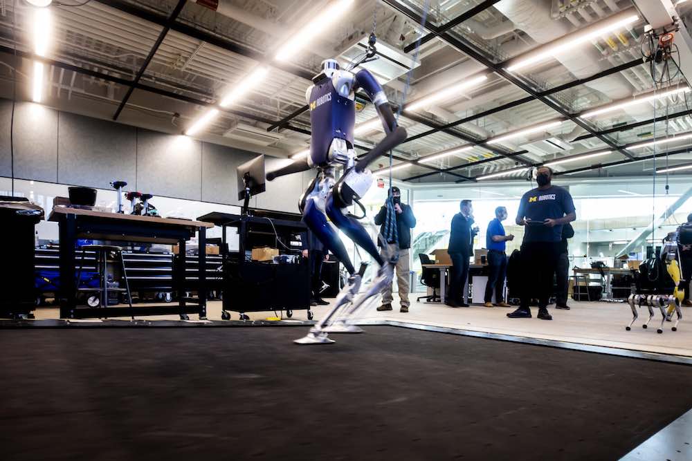